Footprints Adventure Tours Recommended in several travel guide book
For Our Best Service & Itinerary Design .!

Ladakh Must Visit Destinations Packages

Leh Nubra Valley Pangong Lake Tsomoriri Lake Delhi, India

Ladakh Tour Package

8 days 7 nights

Leh Khardung-La Top

Ladakh Tour Package

4 days 3 nights

Leh Alchi Nubra Valley Pangong Lake Delhi, India

Ladakh Tour Package

8 days 7 nights

Srinagar Kargil Padum Zanskar Kargil Dah & Hanu Leh Pangong Lake

Ladakh Tour Package

8 days 7 nights

Leh They Thiksy Hemis Pangong Lake

Ladakh Tour Package

4 days 3 nights

Leh Nubra Valley Pangong Lake Delhi, India

Ladakh Tour Package

6 days 5 nights

Leh Sham Valley Pangong Lake Nubra Valley Tsomoriri Lake

Ladakh Tour Package

7 days 6 nights

Leh Sham Valley Nubra Valley Pangong Lake Delhi, India

Ladakh Tour Package

6 days 5 nights

Leh Sham Valley Nubra Valley Pangong Lake Delhi, India

Ladakh Tour Package

7 days 6 nights

Leh They Thiksy Hemis Nubra Valley Khardung-La Top

Ladakh Tour Package

5 days 4 nights

Leh Sham Valley Pangong Lake

Ladakh Tour Package

7 days 6 nights

Leh Sham Valley Nubra Valley Pangong Lake

Ladakh Tour Package

8 days 7 nights

Leh Alchi Pangong Lake Khardung-La Top

Ladakh Tour Package

6 days 5 nights

Leh Sham Valley Nubra Valley

Ladakh Tour Package

7 days 6 nights

Delhi, India Sham Valley Nubra Valley Leh Pangong Lake

Ladakh Tour Package

6 days 5 nights

Ladakh Star & Deluxe Hotel Packages

Leh Sham Valley Pangong Lake Khardung-La Top

Ladakh Star Hotel Packages

5 days 4 nights

Leh Pangong Lake Khardung-La Top

Ladakh Deluxe Hotel Packages Family Package

5 days 4 nights

Leh Pangong Lake Khardung-La Top

Ladakh Star Hotel Packages

5 days 4 nights

Leh Pangong Lake Khardung-La Top

Ladakh Star Hotel Packages

5 days 4 nights

Why Book With Us?

 
Best Price Guarantee

 You are guaranteed getting the lowest Ladakh tour package & hotel booking price if book with us, since we are based locally, there is no hidden cost, add-on commissions, or any third party handover of your tours operation.With our payment system you can avail easy EMI options too. We let you travel first and pay later.

 
Trust & Safety

We use the latest line of transport (Innova Zylo cars & Mini turbo bus) well trained drivers with mountain driving license. Our guides are trained for high altitude and mountain sickness rescue.To secure your payments, we use CCAvenue payment gateway with easy EMI.

 
Best Travel Agent

Served more than 1000-plus guest every year, recommended in many tour guide books. We are among the oldest tour companies in Ladakh. Our representative are ready to attain you 24/7 while you're in Ladakh. Booking with us your tour and money is always in safe hand.

About Ladakh

Rock carvings found in many parts of Ladakh indicate that the area has been inhabited from Neolithic times.[12] Ladakh’s earliest inhabitants consisted of a mixed Indo-Aryanpopulation of Mons and Dards,[14] who find mention in the works of Herodotus,[b]NearchusMegasthenesPliny,Ptolemy, and the geographical lists of the Puranas.[15]Around the 1st century, Ladakh was a part of the Kushana empire. Buddhism spread into western Ladakh from Kashmir in the 2nd century when much of eastern Ladakh and western Tibet was still practising the Bon religion. The 7th century Buddhist traveler Xuanzang describes the region in his accounts.[e]

In the 8th century, Ladakh was involved in the clash between Tibetan expansion pressing from the East and Chinese influence exerted from Central Asia through the passes. Suzerainty over Ladakh frequently changed hands between China and Tibet. In 842 Nyima-Gon, a Tibetan royal representative annexed Ladakh for himself after the break-up of the Tibetan empire, and founded a separate Ladakhi dynasty. During this period Ladakh acquired a predominantly Tibetan population. The dynasty spearheaded the second spreading of Buddhism, importing religious ideas from north-west India, particularly from Kashmir. The first spreading of Buddhism was the one in Tibet proper.

According to Rolf Alfred Stein, author of Tibetan Civilization, the area of Zhangzhung was not historically a part of Tibet and was a distinctly foreign territory to the Tibetans. According to Rolf Alfred Stein,[16]

“… Then further west, The Tibetans encountered a distinctly foreign nation — Shangshung, with its capital at Khyunglung. Mt. Kailāśa(Tise) and Lake Manasarovar formed part of this country, whose language has come down to us through early documents. Though still unidentified, it seems to be Indo-European. … Geographically the country was certainly open to India, both through Nepal and by way of Kashmir and Ladakh. Kailāśa is a holy place for the Indians, who make pilgrimages to it. No one knows how long they have done so, but the cult may well go back to the times when Shangshung was still independent of Tibet.
How far Zhangzhung stretched to the north, east and west is a mystery … We have already had an occasion to remark that Shangshung, embracing Kailāśa sacred Mount of the Hindus, may once have had a religion largely borrowed from Hinduism. The situation may even have lasted for quite a long time. In fact, about 950, the Hindu King of Kabulhad a statue of Vişņu, of the Kashmiri type (with three heads), which he claimed had been given him by the king of the Bhota (Tibetans) who, in turn had obtained it from Kailāśa.”

A chronicle of Ladakh compiled in the 17th century called the La dvags royal rabs, meaning the Royal Chronicle of the Kings of Ladakh recorded that this boundary was traditional and well-known. The first part of the Chronicle was written in the years 1610–1640 and the second half towards the end of the 17th century. The work has been translated into English by A. H. Francke and published in 1926 in Calcutta titled the Antiquities of Indian Tibet. In volume 2, the Ladakhi Chronicle describes the partition by King Skyid-lde-ngima-gon of his kingdom between his three sons, and then the chronicle described the extent of territory secured by that son. The following quotation is from page 94 of this book:

He gave to each of his sons a separate kingdom, viz., to the eldest Dpal-gyi-gon, Maryul of Mngah-ris, the inhabitants using black bows; ru-thogs of the east and the Gold-mine of Hgog; nearer this way Lde-mchog-dkar-po; at the frontier ra-ba-dmar-po; Wam-le, to the top of the pass of the Yi-mig rock …

From a perusal of the aforesaid work, It is evident that Rudokh was an integral part of Ladakh. Even after the family partition, Rudok continued to be part of Ladakh. Maryul meaning lowlands was a name given to a part of Ladakh. Even at that time, i.e. in the 10th century, Rudok was an integral part of Ladakh and Lde-mchog-dkar-po, i.e., Demchok was an integral part of Ladakh.

Faced with the Islamic conquest of South Asia in the 13th century, Ladakh chose to seek and accept guidance in religious matters from Tibet. For nearly two centuries till about 1600, Ladakh was subject to raids and invasions from neighbouring Muslim states, which led to the partial conversion of Ladakhis to Noorbakshi Islam.

How To Reach Ladakh

Ladakh by Flight

The nearest airport is at Leh, which is well connected to Delhi, Jammu, Srinagar, Chandigarh, Mumbai . From the Leh airport, hire a cab to reach Leh city has several accommodation options. Nearest Airport: Leh Airport (IXL) - 5 kms from Leh town  

Ladakh by Road

Road If you don't want to take flight, then you will have to reach Manali or Srinagar via trains and buses and then from Manali or Srinagar, you can catch a bus or a cab or even a shared taxi that drops you directly to Leh. The road from Manali to Leh is said to be one of the most picturesque routes of the world. A lot of people cover this route on their motorbikes, especially on Royal Enfield motorcycles as the terrain is a bit bumpy. Some cycle enthusiasts also cover this distance over their bycycles. 

Ladakh by Train

As mentioned, the city is at a very remote location with minimal resources available. So the region does not have a railway station. However, the nearest railway station is Jammu Tawi (700 km from Ladakh) which is well connected with Delhi, Kolkata, and Mumbai.

Commuting Within Ladakh

The mystic and awe striking region of Ladakh is surrounded with gorgeous scenery and travelling through this region can indeed be a pleasure. There are buses, taxis, motorcycles and bicycles available for getting across Ladakh and you can choose the one that you deem fit.

Book Ladakh Star & Deluxe Hotels, Guest Houses, Camps & Homestay

Directly with Local owners in Leh, Kargil, Nubra & Pangong lake

Save upto 25%

Best price - Guaranteed

From Rs.3500 to Rs. 1000 / Room

Know More
 

Travellers Reviews

Unpublished


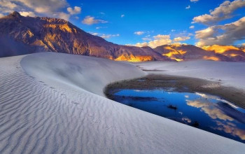
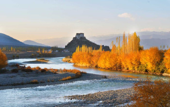
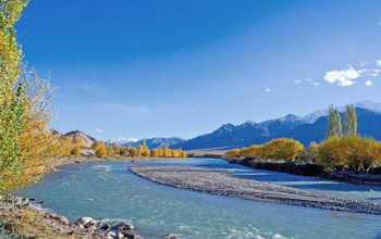
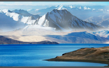
Nubra (Tibetan : ལྡུམ་ར; Wylie : ldum ra; English : Nubra) is a tri-armed valley located to the north east of Ladakh valley. Diskit the capital of Nubra is about 150 km north from Leh town, the capital of Ladakh district, India. Local scholars say that its original name was Ldumra (the valley of flowers). The Shyok River meets the Nubra or Siachan River to form a large valley that separates the Ladakh and Karakoram Ranges. The Shyok river is a tributary of the Indus river. The average altitude of the valley is about 10,000 ft. i.e. 3048 metres above the sea level. The common way to access this valley is to travel over the Khardung La pass from Leh town. Foreign nationals are required to get a Protected area permit to visit the Nubra Valley. Since 1 May 2014 Indian citizens are no longer required to get an Inner Line Permit to visit the valley.


Geography[edit]

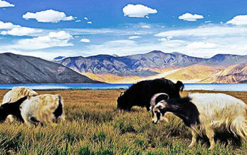
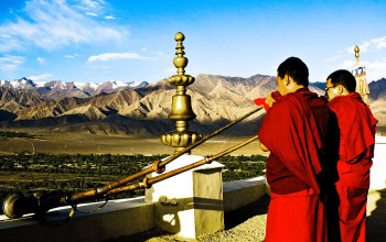
Like the rest of the Tibetan Plateau, Nubra is a high altitude cold desert with rare precipitation and scant vegetation except along river beds. The villages are irrigated and fertile, producing wheat, barley, peas, mustard and a variety of fruits and nuts, including blood apples, walnuts, apricots and even a few almond trees. Most of the Nubra Valley is inhabited by Nubra dialect or Nubra Skat speakers. The majority are Buddhists. In the western or lowest altitude end of Nubra Valley near the Line of Control i.e. the Indo-Pak border, along the Shyok River, the inhabitants are Balti of Gilgit-Baltistan, who speak Balti, and are Shia and Sufia Nurbakhshia Muslims.

Siachen Glacier lies to the north of the valley. The Sasser Pass and the famous Karakoram Pass lie to the northwest of the valley and connect Nubra with Uyghur (Mandarin : Xinjiang). Previously there was much trade passing through the area with western China's Xinjiang and Central Asia. The people of Baltistan also used the Nubra valley for passage to Tibet.[1]

Places[edit]

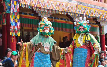
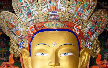
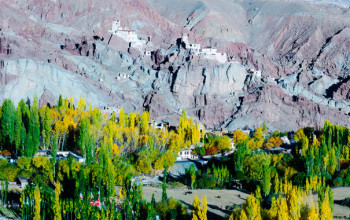
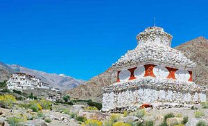
Diskit town in the valley have become the congregation centre for people of the region. Diskit is the headquarters of the Nubra Valley and thus has lot of government offices with basic facilities. It is also connected by road with Leh. The 32 metre Maitreya Buddha statue is the landmark of Nubra Valley and is maintained by the Diskit Monastery.

Along the Nubra or Siachan River lie the villages of Sumur, Kyagar (called Tiger by the Indian Army), Tirith, Panamik, Turtuk and many others. Samstanling monastery is between Kyagar and Sumur villages, and Panamik is noted for its hot springs. Across the Nubra or Siachan River at Panamik, is the isolated Ensa Gompa.

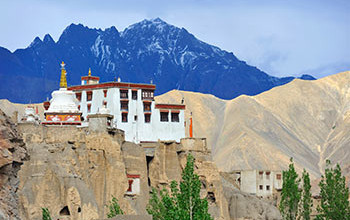
On the Shyok (pronounced Shayok) River, the main village, Diskit, is home to the dramatically positioned Diskit Monastery which is built in 1420 AD. Hundar was the capital of the erstwhile Nubra kingdom in the 17th century, and is home to the Chamba Gompa. Between Hundar and Diskit lie several kilometres of sand dunes, and (two-humped) bactrian camels graze in the neighbouring "forests" of seabuckthorn. Non-locals are not allowed below Hundar village into the Balti area, as it is a border area. The beautiful village of Baigdandu is also located in this area. There is a marked presence of people with startling blue eyes, auburn hair and rosy cheeks as against the typical mongoloid features of the Ladakhis. Local lore has it that they were a Greek tribe who came in search of Jesus Christ's tomb and eventually settled here. Baigdandu is also known for the goats that give you the famous Pashmina shawls.

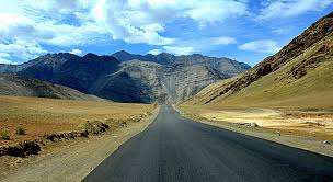
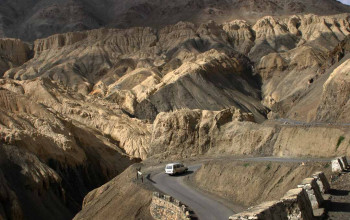
The main road access to the Nubra Valley is over Khardung La pass which is open throughout the year. Its status as the highest motorable road in the world is no longer accepted by most authorities. An alternative route, opened in 2008, crosses the Wari La from Sakti, to the east of Khardung La, connecting to the main Nubra road system via Agham and Khalsar along the Shyok River. There are also trekkable passes over the Ladakh Range from the Indus Valley at various points. Routes from Nubra to Baltistan and Yarkand, though historically important, have been closed since 1947 and 1950 respectively.

The valley was open for tourists till Hunder (the land of sand dunes) until 2010. The region beyond Hunder gives way to a greener region of Ladakh because of its lower altitude. The village of Turtuk which was unseen by tourists till 2010 is a virgin destination for people who seek peace and an interaction with a tribal community of Ladakh. The village is stuffed with apricot trees and children. The local tribe, Balti, follows its age old customs in their lifestyle and speak a language which is just spoken and not written. For tourists Turtuk offers serene camping sites with environment friendly infrastructure.

 
Sand Dunes of Nubra valley

Education[edit]

The valley has been secluded as has been most of the exterior parts of Ladakh. Almost all of the region has been facing problems to get good quality education. There have been initiatives in the past by the government but extreme weather conditions and vicinity to the borders have been a major hurdle in implementing a solid education base. There is also migration of the population that gets exposed to the big cities of India and hence the people do not get benefitted out of their local learned population. There are very few Non-Government organizations active in Nubra region. A national NGO karmabhoomi works for the education and employment generation in the Turtuk region with an intention to cover the whole of Ladakh in future.

Nubra is a tributary of the Indus river.